Mountain Building Lesson
Learning Objectives:
Illinois State Board of Education (ISBE) Middle School Standard E: 12.E.3a Analyze and explain large-scale dynamic forces, events and processes that affect the Earth’s land, water and atmospheric systems (e.g., jetstream, hurricanes, plate tectonics).
Lesson Description:
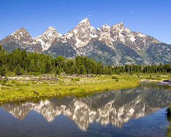
During this lesson, students will explore how and where mountains form. Students will model folded mountains with play dough. Students will be given different colors of play dough to use to form a model of a lithospheric plate with the colors representing different sedimentary layers. Students will record observations about their plates and draw a side view of their layered plates. At the beginning of the activity, each student's plate should consist of layers of different colored play dough stacked on top of each other. Then, to simulate compression, students will place their hand, one on either end of their model plate, and slowly push their hands together. The play dough layers will fold and buckle creating upward folds (anticline) and downward folds (syncline). Students will be asked what might cause similar compression to the lithospheric plates on the earth's surface. Then, students will be asked where this might occur. After the folding and class discussion, students will then draw their plate and record new observations. Students will then be shown pictures of actual folded rocks and compare and contrast the photos with their play dough models in a class discussion setting.
After the discussion, students will make 2 new layered plates just like in the previous activity. They will then slowly push the two new plates together and record their observations and a drawing of what happens. Then, referring back to previous lessons, there will be a classroom discussion about the different ways mountains form. Students will be asked to connect today's activities to previous lessons.
- Students will be able to identify what causes mountain formation
- Students will be able to identify the type of plate boundaries that corresponds to a particular mountain shape
Illinois State Board of Education (ISBE) Middle School Standard E: 12.E.3a Analyze and explain large-scale dynamic forces, events and processes that affect the Earth’s land, water and atmospheric systems (e.g., jetstream, hurricanes, plate tectonics).
Lesson Description:
During this lesson, students will explore how and where mountains form. Students will model folded mountains with play dough. Students will be given different colors of play dough to use to form a model of a lithospheric plate with the colors representing different sedimentary layers. Students will record observations about their plates and draw a side view of their layered plates. At the beginning of the activity, each student's plate should consist of layers of different colored play dough stacked on top of each other. Then, to simulate compression, students will place their hand, one on either end of their model plate, and slowly push their hands together. The play dough layers will fold and buckle creating upward folds (anticline) and downward folds (syncline). Students will be asked what might cause similar compression to the lithospheric plates on the earth's surface. Then, students will be asked where this might occur. After the folding and class discussion, students will then draw their plate and record new observations. Students will then be shown pictures of actual folded rocks and compare and contrast the photos with their play dough models in a class discussion setting.
After the discussion, students will make 2 new layered plates just like in the previous activity. They will then slowly push the two new plates together and record their observations and a drawing of what happens. Then, referring back to previous lessons, there will be a classroom discussion about the different ways mountains form. Students will be asked to connect today's activities to previous lessons.
